ST MICHAEL'S
The Flood Plain Question
But the question of the Flood Plain that appeared on earlier
maps and then disappeared off the later ones is discussed
on this page .
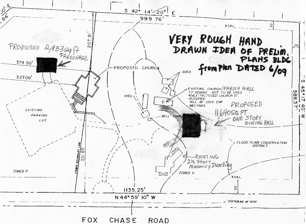
The new building is being proposed in an
area that was noted as
Flood
Plain Conservation District in earlier plans. It
does not appear as a Flood Plain or Flood Plain Conservation
District on the new FEMA maps that as of 11-11 are waiting for
adoption - nor does it appear on the new ST Michael's plan.
So we set about trying to figure out who had decided it was no
longer a floodplain
We asked about the documentation for that change.
What appears to have happened here is possibly that FEMA never
actually had the Floodplain Conservation District on their maps.
A letter that we have indicates St Michaels had to contact
DER or the Army Corps of Engineers back in 1990 and
they apparently were the ones that indicated the Ha soil was to
be designated
as flood plain area - St. Michael's then apparently
noted the Floodplain Conservation District
(which is the terminology
for the zoning overlay
of a flood plain area) on their plan . FEMA may never have
picked up that information when they created their maps.
BELOW ARE NOTES ABOUT HOW A FLOOD PLAN CAN BE CHANGED
AND THEN THE GUIDELINES FOR THE FLOOD PLAIN DISTRICT
HOW
A FLOOD PLAIN IS CHANGED
http://www.fema.gov/pdf/floodplain/nfip_sg_unit_4.pdf
There are two types of Letters of Map Change (LOMC):
a Letter of Map Revision, or LOMR,
and a Letter of Map Amendment, or LOMA
. The terms relate to the map changes described in the
previous section. A “LOMR-F” refers to a LOMR based on new fill
in the floodplain. Because such a letter officially amends or
revises the effective NFIP map,
it is a public record that the
community must maintain. Any LOMC should be noted on the
community’s master flood maps and filed by panel number in an
accessible location. Using NFIP Studies and Maps 4-21 …………
requests for map changes should be completed by a qualified
engineer or surveyor. The most common reason that a map change
request is not completed is that the applicant did not submit
adequate technical data to validate the change.
.
FLOOD PLAIN CONSERVATION DISTRICT
Note - we have not been able to find the
floodplain conservation district listed on the 2009 plans for
the new construction. It is a very clearly listed on the
1990 plan that was
given by St. Michael's attorney to residents. The soil
sampling designations have significantly changed since the
1990 map.
We have obtained a a full size copy
of the fully approved "Overall Site Plan" (Sheet 1 of 3 by
O'Donnell and Naccarato dated 8-9-89 that shows the Ha soil and
"Flood Plain Conservation District" identically as shown
on the small enclosure letter that we previously referenced
given by St. Michael's lawyer, Stadley, Ronon, Stevens & Young
Law Offices letter to George T. Myers on April 11, 1990 . So
that enclosure with the
drawings
on it shows the new building in the Flood Plain Conserv Dstrct -
but the new plans have the Flood Plain Conserv Dstrct
shifted maybe several hundred feet to the right to exclude the
new building.
ZONING REGULATIONS FOR
503
CONSERVATION DISTRICTS AND 600 FLOOD PLAIN CONSERVATION DISTRICTS
See my highlights on the
illegible copy below
- especially 600.6 / 600.7 D, E &G and 600.9- since I
don't have time to fix the text - here is where to find the
legible copy
CODEBOOK
Part 1
Township's
Codebook except for zoning
Part 2
Zoning Portion of Township Codebook
Illegible excerpt - see parts in yellow:
SECTION
503. RECREATION \
CONSERVATION DISTRICTS
Section
503.1.
Pu r lme : The purpose and intent!
of llle Conservation:RecreationDistrict is to
prolect the To\vn.rliip's natural resources such
as prime agricul~ural soils; stream va:ley areas;
tloodplain aleas; slep slope areas; a~oodlai;d
areas; and scenic cper siles; and to encourage: for
ecological purpo5es; envjro~~n~enlc;oiln
sc:valion; flood water management;
r round
water
recharge; recreation; and other open space
conserva~ion purposes.
Seclion
503.2.
Use Regulalions:
A
building ]nay be erccied. aliered;
c: used, ar:d a la1 may
be occupied o r used; in whole or in p r l , for
any
of the f o l l o ~ v i ~usge s and
rjo
other, prot'ided
i11bt
such uses shall comply wilh the cisiricl
regulalions established in rhis Arlic!e and
all
olhel
applicable sections of this Ordinance.
Section
503.2.A.
Uses Pe~mlilted
by
Right:
1.
E.S: Municipal complex
2.
G-6: Public park or
recrearional area owed and operared by the Township,
olher governn~entalju risdictions, or pri\'ate
non-profit agencies.
3.
H-S: Single-family detached
residential dwelling units which may lawfully
exist wirhin the disiricl prior to the adoption
of this Ordinance.
4 . J-I:
Open space, forest, siream, or wiidlife preserve, or olher
resource conser\'a~ion
pulpose, opeiared essenlially by a non-profit
agency
5. The i
o l l c ~ n ~ ~acncge
ssory uses shali be
pern~iltea:
a. A-2:
Non Residential Accesso:~
S:rilcture: Accessory buildings and uses oil
the same lot whicl~ are customarily incidental
to any permiried use,
including a 6isplay or museum building.
b. A-6:
Fences and Walls
c.
13-1 (Agricullule), and B-3
(Liveslock) as an
accessory use to an unlau*fu!
use established prior to this Ordinance..
d. 1nc.idental use.s lo ourdoor recrealion, such
as cl~arging for admission;
enterrainmeni; or sale of refrcshme~ts; providcd
that any such use shall be
Iocaled and screened so that
i t
shall not be visible irom s1ree:s
or adloining
property
Section
503.2.B.
Uses permitted
by
Conditional Use:
Seclion
503.2.C.
Uses p e r ~ u i ~ t et ~d yS
pecial Exception:
I .
B-I:
Agriculture as a principal use.
2 B-2: Kennel as an accessoq or principal use.
3. B-3:
Liveslock as a principal use.
4. Li-4: Riding Acadcn~y as ail accessoly or
p:incipal use.
5 . C-6:
Country club,
I
c : b lodge, cr ally ot11r1
structure opcrated
in
coiijunctio~lw it11 ;ind ~ncit1e::tal to any
approved or permitted ouldoor
s e : provided the sj~cciald e\elopn~enrie
gulations hercin are satisfied,
ant i
srrvices sl~alib e lin~itetlt o members and guests only,
6, (3-4:
Golf Couise
-
provi2ed illat the following
conditioijs are sat~sfied:
a, Not more than scvexty-five (75) percent
of
the site s11all be
dist3rbed from iis na!ul.al
01.
exisling condition. Every eiforl
shall
be inade to d e i f y and preserve natural
resources such as
flootiplair.,
steep
slope and \~oodlanda l.eas, and any
olher feature
which
:he
Board of Comniissione~ss hall
deem
sjgnificaiit.
Section
503.2.D. Uses
Specifically PI-ohibited:
The
follo\4Gng uses sl~alln ot be
permilled in
this district:
1. Indoo~a.m usement centers
2 .
Outdoor am~sernentp allis and rides, except il~osew. hicl~m ay
be permitted by rlie
T o u ~ ~ s lo~ni p a
temporary basis.
2 a,
Stadiuim used ior conmcrcial purposes
or
as piofit ventures.
4 , Ac c e s
s~i yii ses iiivolvi~~bgu siness operatioils, except as
pernlitted l~eiein
5 .
Signs, except as
peimilted in the sign
provisions.
Section 503.3. Dimer~sional Regulations: The
following dimensional regulations ale !he
dis:rici standards which mus: be achieved for
any use, addition or alteration:
Ncte: Residei~ialB uffer rcqui~cnientsm ay
clla~lge ~ I ~ I I ~
I I pI
aLrId~
sIiz
e.
I
MIKIh~IUhl LOT DIMENSIONS
Lot Area
Lot
\Vidt11 Lot Dcpth
5 acres
I
;OD
feel
XI0
feel
j
h1JSlMUhl YARD DIAIENSION
F~xmt Side
(2) Rear
I
I00
feel
1
50 feel
50
leer
[
COVERAGE
Ma&. Bidg.
Area Mar.
Inlpersio~ts Min. Grzcn
AI-ea
I0 %
E I ~ X
15
9%
n m
8.5 7% ixin
HUlLDING DII\IENSIOh'S
Max. Hciplrf
A h . Length hlin.
Sq~nrntion
35 fi niax
203 f! max
I
35
fi nlin
Section 503.4. Special
De l~e lul~i i l enRte gulations:
A, No b u i
l d i ~ ~ g i n abye
l o c a ~ e dc losel 1ha11c
lie h u n d r e d
(100)
fee: to
an):
street or ploperiy line.
B. All uses
and building designs shall be con~pii!ihle wilk llie nalural
characler of
lhe area and
lhe
cor:sen~aiion inlent of r11c dislricl.
C. Parking
shall meei rhe standards
of
this Ordinal~ce.
D. All
vending machines shall be localed inleinal
lo
a
periniited building
or
~ n d e ri . ~ c a c e
siruclures.
ARTICLE 1'1
Overlay Zoiiing Dislricls
SECTION
600.
FLOOD PLAIN CONSERVATION
OVERLAY DISTRICT
Seclion
600.1.
Purpose and lnlcnl: In [he interesl
of the public lleallh, safely and welfare, !]:is
arlicle is inlended lo prolect areas o i f l c o
d p l a~nh, erein defined as 111e "Flood Plain Co n s e~\~a l i
o r
Overlay Di s i r~c t , "in .4binglon Towns!~ipw
hich are sllbjec: lo and necessaly for
f
oodwa~e r sa. ~ ~ d
lo permit and encourage 111e i e~ent ioco f open
land uses wkich will be so 1oca:ed and designed as
lo conslilute a l i a r~noi~iou2nsd appropr i~t
ep ar1 of Ihe physical devclopnient of l l ~ er nuni c ip~l i~y
as provided
~ O I
i.n
the Comprehensive Plan.
Section
600.2.
Boundxries of
il;?
Dislricl and Defini;ions:
A. The Flood Plain Conservalion Dislrict is
defined and eslablished lo consist of any areas
included in any one of Ihe follo\r4ng:
3 .
Those areas subject to inundation by rhe walers of lhe one-hund~ed-year(
100) flood as
delinealed in ihe Flood Inscrance Study for (he
Township of Abington, h40nlgomery
Couniy, Pennsylvania, asprepared by ihe Federal
Enlergericy Mafiagemen! Agency.
The
Flood Plain Disiricl shall be coinprised of four
(4)
subdislricts, described 3s follows:
a. Floodway
(F1):
That porlion of !he Flood Plain
Disiricr required lo carry and
discharge rhe walers of the oze-hundred-year
(100)
flood \3.~~!houi:; lc;easing !he
waler surface e1eva:ion at any point more t11a11
one (1)
fool above exisling
condirions, as demonstrated in [he Flood
Insurance Swdy referenced above.
Williin any designated floodway area, no
construction, development, use, activity
or encroachment of any kind shall be allowed
excep! wl1el.e ihe effect of such
proposed activity on flood heights is fully
offset by accompznying siream
improvemenls.
b. Floodway Fringe
(FZ):
Those portions of land n~illlin
i11e Flood Plain Districr
subjecl to inundalion by lhe one-hundred-year
(100) flood, lying beyond the
floodway in areas where detailed study dala and
profiles are avai!able.
C .
Approxinlated Flood Plain
(F3):
Those porlions of land wjll~inth e
Fiood Plain
Dislrici subjecl ro inundaijon by llie
one-hundred-year (100) flood: w11ere a
detailed sludy hasnoi beenperformed, bul where a
one-hundred-year (100) flood
plain boundary his been approximaled.
d. Special Flood Plain District (F-4): Those
areas identified as Zone
AE
in lhe
Flood InsuranceStudy, \vheie one-11undl.ed-yea
(100)
(100)flood elevations have
been provided, bul no floodway has been
delinealed. Within the Special Flood
, , Plain
Disiricl, no act:\wy, conslruclion,
develop in en^:
or use shhil be allowed if
it would cause an increase of one
(I)
fool
01.
more
i n rhe
one-liund~ed-yea(r1
01))
flood p:aiii eleva~im
3.
Studies:~std to cstiiblisl: 1l:c bou::dal-ies sllali be
available i l l
the Townsl~iph 4xnicipal
Bui!di~;g
for referelice.
C. The data
in the studies rciel-ei~cec11
1 Subsectio:~1
above sl~allb e ploued on
the Z a ~ ~ iM~ al pg
if, as, and when feasible to indicate t!~eF lood
Plain Consci-va'.ion District. Such n ~ a psh all be
designated as the Towiship Flood Plain
Conse:.valion District Zoning h4ap and sllall be
available to the ~mb l i cin !he To\vnship
h4u1;icipal Building. Wherever Illere is a difiere~lce
between [he ma;, and the data conlained in :Ire
studies, the data contained i n the s:udies shall
determine the boundarirs o i the Flood Plain
Co~:servation Ove:.lay District.
D.
All
subsequent changcs :]made in the boundaries shall, if, and when
feasible, be indicat d on
the Flood Plain Conser\~aliol:D istrict Zoning~M ap,
E,
Development: Dcvelopn-ient in the Flood Plain District boundary
shall i~lclude any manmade
change to improved o r u~~impioveydea 1 estate
including but not limited to: buildings
or other slructu:cs, i l ~ pla cement of
manufactured home, streets, and other paving, utilities,
filling, grading, excavating, mining, dredging,
or drilling operation, and the subdivision of
land.
Section 600.3. Overlay Concept: The Flood Plain
Conservation District shall be demed an
overlay or] any zonillg districi now or
hereafter applicable to a lot.
A, Sl~ouldt he Flood Plain Come:-valion District
be declared inapplicable by legislative or
achinistralise actions ol; by judicial decision,
the zor~ing applicable lo such lot sl~all be
deemed to be in the district in \vl~ich it is
located without consideration of this Article.
B. Should
the
zoning of any parcel or any part
?hereof in wl~ich the Flood Plain Conservation
District is located be changed tl~rouglal ny
legislative action or judicial decision, such cllange
shall have
J IO
effe.c! on the Flood Plain
Conservation Overlay District, u~lless ucl~c l~aligew as
included as part of the original application.
C. In any
zoning district, the
I ~ I ~ ~ I I I I IsIeItIb
ack of ail slructures iron>
tile
cenier line of all
watercourses shall be determined by 111e n~a x i
n~ufnrio nt, rear or side yard requir-enlenls in
the appliczide section of illis Ordinance,
except w11ere Illis Article requires a greater setback,
Section
600.4. Boundary
Dispufes and Appeals:
A. Should a dispute concerning tile Flood Plain
Conservation District boundaries arise, an initial
dcternli~1atiol:s l~all? e made by the Building
Inspector or Code Enforcement Official.
J3. h y p
alty aggrieved by the decision of the Building Inspeclor,
ciain~ingthec ritei.ia used for
delinea!ing the boundary as defii~ed1 1erein or
have become iniorrecl because of changes due
to mtural or ollicr cause, or hecause o i
changes indicated by future delailed l~)~d r o l o gan~dc
hydraulic studies, may appeal lc the Zoning
Healing Bcard as
piovided herein. All c l ~ z
n ~ e s
are subject to the :evjew and comn~enlo f the
Federal lnsurai~ceA dnir1islraljon:
FEh.IA:
and
Ihe Township Engineer.
C Tke buiden of proo!, bolh wi111 r e s~~elcot
going f o rwr d wjlh the evidence and \viih
re spec^
to the burden of pel.sunsion, shall be on the
appellan!.
Section 600.5. Use Regulafions
Section 600.5.12. Perillilted Uses: The
following uses and
110 c,the~e, xce?t such uses
as are
permitled by special exceplion under the pro\;isions
of 1111s Orcinance: shall be pe!n]jlled
]:I
the
Flood Plain Conservaljon Oveilay Dislricl:
1.
Cullivation and har\~es!ii~ogi c:ops according to recognized
soil conserva:ion prac~ices.
2. Paslure
and grazing of animals acccrding
10
recognized soil conser\~atjon
plac~ices
3. Ourdoor plant-nursery or orchard according
10
recognized soil conservation
praclices.
4 .
Halvesling o i any wild clops such as n ~ a i s hh ay, f e ~ n
sm, oss, beriles or w11d rice
5.
Wildlife sancluary, woodland prcscrve, arboreium, passive
recrralion or parks: including
hiking, bicycle and bride lrails,
but including
no facililies subjecr to damage by flooding.
6. Gzme
farms, iish halcl~ery or hunting and fishing reserve
for
the prolec~ion and
propagation of wildlife; but pernilling no
slruclures.
7. Forestry,
and reforestalion according lo recognized narural resources
conservalion
practices
8. Front,
side and rear yards and ~equiredlo t area in any dislricr, pro\'ided
such yards are
not to be used for on-site sewage disposal
systems.
9.
Normal accessory uses except enclosed s1ruclures, fences
and
swimming poolspermitted
under the usual zoning in residenlial,
con~mercial and'industrial distlicls.
a. Exception: Fencing already in exisfence at
the adopiion of this Ordinance
may be maintained and replaced, provided any
replacen~ent is wilh open 111e:al
fencing which provides minimal water flow
in!erference.
Section 600.5.B. Uses P emi t t e d
by
Special Exception: The foilo\4~ingu
ses may be pern3i:led
as a special exception upon l l~ec ondition
lliat no use perinitred as a special exceplioii shall incl.ease
the elevarion of ihe one-hundred-year
(100)-frequency :ecurren! i r , l e l ~fll ood by more lhsn one
( I ) foot
ar any poiill:
1.
Kecxatimal use, wlietl~erc pel; lo the pAl i c or :-estrjcled to
pr~va l ein enibership; s-ch
as pa; ks; c;rn?ps; picnic areas; golf coiixes;
lislling m a s ; spolt or boatil~gc lubs; not
:o
includc elxlosec! s1rl;cturcs exccpl toilet f ~
i l i i i e sb,u t ~ ~ e r n ~ i l t1i:niegls ; docks; floats;
or
unenclosed shelters usually found in developed
o::door recreational areas. Any toilet
iaciliiies provided shal! be connected to public
water and sewerage systems.
2. Sewage
trealn~ellt plan:, outlet :nstallations for sewage ileatnlent
pla~ts. and senrage
~ u n ~ p i nstg2 :ions; with tile :~pprosal of
the To\vnship Engineer, app:opriate sewer
authorities and the Pmis)~lvania Departnlent of
Environmental Resources, wl~en
accompanied
by
documentation as to the necessity
for locating willlin the boundaries of
the I;lood Plailr Conservatiori Overlay Disirict.
3. Sealed
puL:lic-watel sr~pply\. ;ells, wit11 the approval of the
Pennsylvania Departnlent of
Envirol~niental Resources.
4. Dams,
culve~ts and bridges, with the approval of appropriate
authorities having
jurisdiction, such as the Commonwealth of
Pennsylvania and Department of
Environn~r:ntal Resources.
5.
Sanitary oi storm sewers and impoundinent basins, wit11 the
appro\:al of the Township
Engineer and the Pennsylvania Department of
Environmental Resources.
6. Roads,
driveways, and parking facililies, subject to the following
conditions:
a.
In the
case of roads and driveways, no such facilities shall be
permitted as a
special
exception if viable alternative alignnlents are
feasible. In any case, pervious rather
than impervious~naterialss hall be utilized in
the construction of any road or drivc\vay
situated wi:hin a floodplain,
b, In 1l:e case of
parking facilities, no such
facility shall be permitted as a special
escep!ion unless satisbctoly evidence is
submitted that such parking \vill not he
utili7.ed duriilg pel-iods of flood flow,
thus
posing no illreat to !he safety of the
vehicles, their users, and/or to Oownstream
properties. Telnpclary parking for
periods not to exceed one (1) hour and/or
parking for recreation uses would be
exalnples of suc11 excep~ions.I n any case,
pervious rall~erth an ilapervious nlaterials
shall be utilized in the construction of any
parking facility situated \villtin a
floodplain.
7. Grading or legrading of lands, including the
deposit of topsoils and the grading thereof.
The application for a special exception for such
a use shall be accompanied by the
following:
a. Detailed engineering studies indicating the
effects on dl-ainage and streams on all
adjaceat properties: as well as the property in
question, including the necessary data
to delerniine wl:etl~ertl lc boundaries ofthe
Flood Plain Conservalior Overlay District
\ ~ o u l db e affected if l l ~ eap p1ics:ioii
wele granred
b. Aii
applicalion for amending ihe bouncalies o!llie Flood 1'1ai11
Conservation OvelIa>~
Dislricl if ihe boundaries are affected by llie
grading or regi.ading of 1;il:d.
c. A
plan indicaling ihe delmsilion of
an)!
fill or inalerials proposed lo be
deposited by
the grading or regradingofland; ruch fill or
olher r~a l e r i i l rs llall be prolecred against
erosion by rip rap, vegeta~ive cover, or
bulkheading.
S. Fences;
except as for replacement of exisling as nole al?o\,e
9. Utilily
transn~ission lines
10. Uses
riinilar to the above w111ch are in conipliance with the inlent
oilhis A~:icle.
Section 600.5.C. Prohibited Uses: The f o l l o
~ ~ ~ui nsegs shall not be permilled lo be hereafter
initiated or expanded in the Flood Plain
Conservalion Overlay Districi:
1.
All
freestanding struclures and buildings and retainiiig \ualls:
with the exception of
flood-relention dams, culverls, and bridges, as
approved by the Pennsylvai:ia Department
of Environmenlal Resources.
2 . The
filling of or reinoval of topsoil from all floodplain lands
as
defined herein, except
as approved by special exception under the
provisions of !his Grdinance.
3 . The
~.elocatiano f any walercourse, wirhout approval by the Board of
Corn~nissione~ofs
Abington Township \vliicl~ sl~all first have
received the rec.onimendation thereon of the
Township Planning Commission, the Soil
Conservation Service, United Stales
Departmen1 of Agriculture, FEMA, and llie
Pecnsylvania Deparlment of Environn~enial
Resources.
4 . Sanilary
landfills, dumps, junkyards, outdoor storage of vehicles and
materials
5.
On-site
sewage disposal systems.
6.
Private water supply
\veils,
Section 600.6.
Applicalion
Procedure
A. For any use of land in the Flood Plain Conser\.ation
Ove~l ayD islric~e, xcept uses exisling as
oillie date of ihe enac~menot ilhis Article, an
applicatioii for
a
floodplain use permii sllall
he filed
with the Planning and Zoning Official who shall
niake an initial determination or the comp1e1e~iess
of the a]:plicalion.
1.
For a use
olllel. lhaii lliose permifled above,
zn
applicalion seeking approval
1>y
special
a.
A plan cccrtifiei by a
registered p~ofcssiona! enginee: w11ich accura!cly locates lllc
floodplaii~p roposal wi:h respect to tlie
floodplail-: district l i :~~i tcsh, annel
or
sticam,
xis sting
floodplain dcvelopn~en:~:o: ge:l~er\ vili1 a l l perlinenl
information such as the
likture of the proposal; legal description of
:he property fill limits, and elevations and
flood-proofing measures, including those
required by
lhe Towns!lip Bujlding Code,
ss amended to ?ale of a!!plicalion, and the
provisions of :his Ar:icle,
b. As
much of the followingaddiiional
informatiox as is deemed necessary by eiil~erth e
Planning and Zoning Official, the Townsllip
Engineer, or :he Zo~iingH earing Board
for the evaluation of efficts of the proposal
upon flood flows and floodplain storage
and to :-ender a decision on :he proposed
floodplain use:
I). A typical valley cross section sl~o\vingtl~chea
nnel of Ihe slicani, the floodplain
adjoining each side of !he cl~annel,c ross-sectional
area to be occupied by the
proposed d e v e l o p t n t , and high-water
ififormation.
(21,
Plan surface view s!!cwing evalneti?!?
01
confours of
!I:
g:oszd; per!ine:~!
slrxture, fill or sto:-age elevalions; size,
location and spatial arrangement of all
proposed and existing structures on the site;
location and elevalions of streeis,
water supnly, sanilary facililies and soil lypes
and other pe.rli~lenitf ifor~nation.
(3).
Profile showing the slope of the bottom of the channel or flow
line of !he
stream.
(4).
Specificalions for building construction and nialer-ials,
flood-proofing, filling,
dredging, glmding, channel improven~en:,s lorage
of mater-ials, water supply and
sanitary facilities.
(5).
A
plan or document cerliiied by a
regisreled p~.ofessional engineer that the
flood-proofing measures are consistent with !he
flood-pro:eclion eleva~ionf or
the particular area, lo include:
(a). A~lchorage to resist floration and lateral
movements
(b) Inslallation of waterlighl doors, bulhl~eads
and shutters
(c). Reinforcemenl of walls lo iesjsl water
pressules.
(d). Use of
l~ilii~lnsl,e n~blme so r nlorlar lo :educe seepage of water
thlough
walls.
( e ) Addirions of mass or weig111 lo slr.xlurcs
lo sesisl flolalioll
(
Installalion of pumps lo lower. watt: l t \ ~ l
isn
slruclures
(g).
Construc~ior of waler supply and wasle rlezlnlent syslems so as
lo
prevenl 111e enlrance of iloodwaters.
(11). Pu n~p i i~g f i i c~l ifoi ire s~u
b-surface exlernal fniinda~ionw d1 and besenlent
floor pressuies.
(I). Construction to resisl rqfure or collapse
caused by water pressure
01
floaring debris.
(i). Cutoff
vaIves on sewer lines or the elirninalion oigravil)! flow
basemen1
drains.
(k).
Elevation of slructures to :educe the likelil~oodo f flood
damage
Scction
600.6.3. Procedures for
Spccial Exception or Variance:
All applications for approvzl
by special exception or variance shall be filed
and processed acco~dinglo !he procedures set for111
in this Ordinalice,
as
vvell as the piecedures
se!
forth in i s l r ~ i c l e In
ccnsidering such
applica~ioix1, 11eZ oning Hearing Board shall
use the s~andardse l forth herein
l o
detrlinine ifllle
use is applopr.iale.
I . The Zoning Hearing Board shall hold a public
hearing within sixt)~( 60) days zfler an
application is filed.
2. The Zoning Hearing Boa] d sl~al]l q u e s t
[he review and recommendation
of
the folIo\ving
agencies:
a. Abinplcn 'I'ownship Planning Con~n~ission
b.
Pennypack
Waieislled Association, Tacony Creek Waletslled Associaion
or
Wissal~ickcnV alley Wale~shedA ssociation as
appropliate.
c. Soil Coiiservalinn Service.
d . United Stzles Deparli~~enoft Agriculture.
e. United Slates Army Coips of Engineers.
f .
Fede~alE
melgency Managen~erA,~g ency.
Section
600.7.
Staritlards f o r .4])11ro\~alo f
S1)ecial Exceplioil o r Variance: Tile Zoning
13-aring Boaid sliall exercise discrrliol~, al!o\vin~
oniy lliose uses \41icll are substir~iiially
in
accordance \~,?itl; l!ie sla:ed objcclises h e~e
i n . 11 :
co~isidc;inga n application for
special exceptio~;
or valiance, the Zoning Hea:-ing Board sllall
consider !he iollowing iii xJdiiioll to the al~propriate
standards set forth above:
T!le effect of :lie use sliall ncl subsiantia!ly
alrer t;:e cross-sectional proiile oithc streams and
floodplains at the location of lhc proposed use.
La:~ds abutting 111e waterway, bolli
ups tie an^
ai:d downstream, shall not be
uii1.easonab1)~
afiected by the proposed use.
The general welfare or public inleres: of
Abinglon Townsl~ipo r of other lnunicipalities in the
same watirshed shall not be adversely afiecled.
, b y structures permilied by special exception
or variance shall be constiucted and placed on
the lo!
SO
as to offer the minimun~o
bstruction to the flow of water and shall be designed to
have a minimun~ effect upon the flow and height
of floodwater. All new construc~ion shall
liave the Io\vest floor, including the basenlent,
elevated to one (1)
foot above the
one-hundred-year (100) flood elevztion.
h y st
ructures permitted by special excepljon or variance shall
include appropriate floodcroofing
measures, incll~dingtl iose required
by
!lie To\rrn?hip Building Code, as
smended to
date of appljcation, and 111e provisions of this
Article.
Mfir~native decisions shall only be issued upon
determination that it is the minimum
necessary, considering the flood hazard, lo
afford relief. An affinnativc decision slmll not be
issued by the Zoning He a r~ngB oard witlin the
designated floodway if any increase in ;he
flood levels during the base flood discha~gew
ould resull. An affirmative decisioj~ b
y lhe
Tonwsliip Zor.ing Hearing Board ~ i l l ~lillne
Special Flood Plain District sliall not be granted
if the activity, construc~ion, developmenl, or
use s!~ould caxse an j~lcrease of one
(1)
foot or
more jn the one-liundred-year
(100)
flood plain elevation,
Mii:-malive decisions shall only bc issged bp
the Zoning Hearing Board upoil
a
sl~o\vingof
good and sufficient cause; a determination that
failure to grant the appeal \vould result in
exceptional l~ardshipto the applicant; and a
delern~inationth at the granting of an appeal will
nct result in increased flood heights,
additional threats to public safety, extraordinary public
expense, creale iiuisances, cause fraud on or
victiinizalion of [lie public, or conflict with
existing local laws or ordinances.
The Zonins Hearins Board shall notify the
applicant in writil~g over tije signa!ure of
comnunity officials Illat [lie issuance of a
decision to allow construclion of a structure below
lllc base flood e l e \ ~ a t i ow~il~l result
in iacreased preiniuln raies for flood insurallce and rhaf
scch co~;slruction below the base flood ele\ralion
increases iisks to liie and proptit)'. Such
~~otiflcatiosnh all be maintained with a record
of all decisions as iequiied ahovc.
I . The
Zonil:g Hearing Board sIlal1 n~ai~ilaiai lr ecord of
ill1
decisicl:~;~ rlcludingju
slific;l:jor~f or
I l l e i r
issuance, a ~ l dre post such decisions issued
i n ils
allilual reporl s;lhnli:led lo !he
Feiesal
Jnsulance Adminisr~a ~ i o a .
Secrioii
600.S. Uses
01.
Struclures Rentlerrd
NonconSo~~~ningFo: llo\l;ing [he adol~tiono f tliis
Ordinance,
any
use or slruclure which
is
sjlualed wiihin the boundaries oi
lhe FP Flood Plaill
Consewation Ove1.1;iyD istrjcl arla
M ~ I I ~ C IdI
o es no1 confor~nlo the
pern1i:led uses speciiied herein,
sllall become a non-co~~foiininugse or slruclure,
regardless of its conforinence lo rhe districr in
whic11 i t
is
Iocaled williaul consideralion of
:his Arlicle.
The expansion or co~llinuanceo f a nonconforming
use or slruclure whicll is nonconforming
will1 respecl lo lhe districl in u;liich
i l
is located n'i:I~oul consitleraiion
of [his Ariicle shaIl be
governed as slipulared in the on-conforn~ing use
seclion of 1 h i
O~
rdinance. However, \he
Zoning Hearing B o a ~ dsh all ensure thar rhe
slandards conlained wirliii~th is Arljcle are ~ppl i ed
lo lhe expansion or conlinuance of said non-confornling
use or slrucrurr. which does lie wi~h
a floodplain.
The expansion
01
conlinuance of
a
nonconforn~ing use or structule
which is rendered
nonconforining due io the adoplion of [his
Arlicle shall be governed by the slandards
contained in this Ordinance. The Zoning Hearing
Board shall rnsure Illat lhose siandards are
enforced with respecl lo said nonconforn~ingu se
or struclure.
All
improvemecls :o existing slructures shall be conrlrucled so
]hat:
I . I~nprovemenlsl o ~esidenlials lruciures
shall be elevared lo rhe gealesl cxrcnt possible.
AJIY p o ~ t i o no f [he sliuctuie not elevated
lo one (1) fool above 111e one-hundred-year
(100) flood
elevalion shall meet lhe requireinents of Suhsectio~i
3.b below.
2.
Improvemenlstonon-residential
strucrures shall
be flood-proofed
oneioot above ihe onehundred-
year
(100) floodplain eleva~iona, ccording to the classifications
\V"
-
W2
of the
Flood-Proofing Regulalio~is,U niled Stales Army
Corps of Engineers: pamphlel
EP
1165
2 314.
or as arnended.
Section
600.9.
Certificate of Compliance:
I . No \man1
land shall be occupied or used, 2nd no building Iiereaflei
erecled, altered, or
moved on {he floodplains of any river or slreanl
shall be occupied or used, unlil a
cerlificale of coinpliance shall have been
issued by lhe Building Inspeclor.
2. The
Building 11:speclor ma); require lhe applicanl lo submil a
cer~ificaljon by regis!ered
professional engineer
01.
land surveyor Illat lhe finished
fill md building floor elevations
and flood.proofing measules or olher
flood.pro~ecrioim~e asures were accomplished in
coi?~pliancew illl !he pro\~isionso f lhis
Arricle.
3 , The
Building Inspeclor shall: wi111int en
(10)
days zfter receipi of such
cer~ifica~iofrno m
lhe applicant, issue
a
cerlificale of compliance only if
111eb uilding or p~eniires2 nd !he
proposed use 11lereof c o~~f o lwn li1 11
all
the rerjuirel~lenir;o f :his
As~icle.
3, The
deg,:ee o i flood pl-olcc~~oin1 ended
10
be
jxovided by ibis Arlicle
is
considered
reasonable ioi regulalory purposes and is base2
oil engineering and scien~ifici neil~odso l
study. This Ar:icle docs not imply ihal areas
outside Flood Plain Conservation 0ve:iiiy
Dis!~ict boui~ia:ies
or
land x e s pemilied \villiin sucli
dislric!~ will always
be
101alIy
free
i m n flooding or flood damages and shall creak
r.o liability upon Abinglon Townsl~ip, its
officials or employees.
__________________________
 Please feel free to
contact us
with your own
information on these topics and please be sure
to
contact us
about any information you believe to be
incorrect -
Please feel free to
contact us
with your own
information on these topics and please be sure
to
contact us
about any information you believe to be
incorrect -
|