ST MICHAEL'S
Soil Changes
(
for
Floodplain changes click here )
__________
 This
issue of shifting soils we now consider to be somewhat resolved.
We did a great deal of research tracking down how the two
different plot plans could be different. It appears that
there is a good possibility in 1990 when the engineer
transferred the information to his map, he did it rather
freehand and loosely and did not copy it correctly. We
took a look at the map he copied it from, and although we
couldn't tell exactly where the borders were we did know that
the shape of the borders looked more like the current soil map.
So we are considering this issue of shifting soils to be
resolved. This
issue of shifting soils we now consider to be somewhat resolved.
We did a great deal of research tracking down how the two
different plot plans could be different. It appears that
there is a good possibility in 1990 when the engineer
transferred the information to his map, he did it rather
freehand and loosely and did not copy it correctly. We
took a look at the map he copied it from, and although we
couldn't tell exactly where the borders were we did know that
the shape of the borders looked more like the current soil map.
So we are considering this issue of shifting soils to be
resolved.
Click here for
Soil Report received 11-9-11 This is a very complete
20 some page study and defines the different soils and some of
the viability for use -- be patient it takes a
minute or two to load
_____________________
Below you can see the two plats or plot plans
that caused the original questions about soils that seemed to
have "shifted" .
KIPLING RD AT TOP
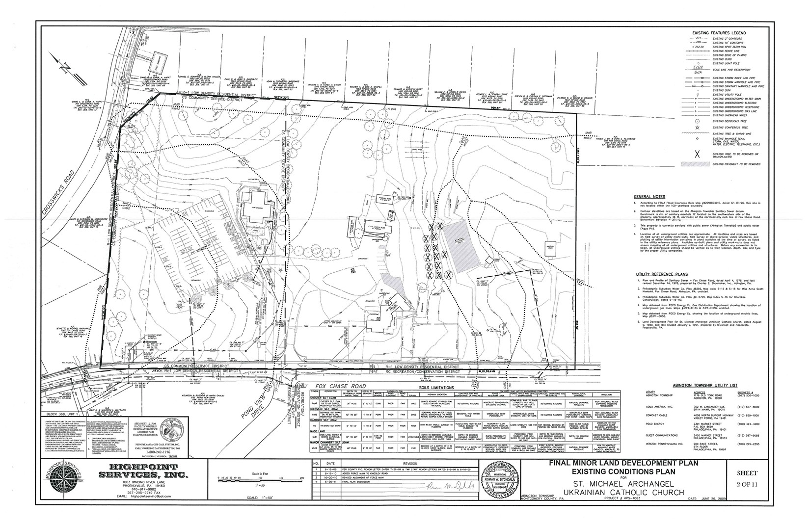
Above :
The grey area on this plan ( above ) on the right is the existing basketball
court. If you look just to the right of the court you'll see
a dotted line in the shape of a "finger & thumb or the end of a
"dog bone" -- that is the soil line .
That soil is Ha- Hatboro loam - a hydrik ( or Heidrick ) soil, often indicative of
wetlands.
Below : In the plan of the same property below you will see the
same soil configuration that is actually labeled as a"flood
plain conservation district" . We were looking for the data
that shows how those soils seemed to keep basically the same
configuration but shift so far to the right . As you can
see on the new plan above, all the building structures are
now outside of those soils . The above new map
does agree with the most recent Department of Agriculture's soil
samplings - new studies were done over the years and the maps
were digitized . We didn't find any data
that would cause a redrawing of the soils map - but having
looked at the 1967 soils map below - it is possible that
the engineer in 1990 did not bring the information over
correctly. Thanks to the folks at DEP & US Dept
Agriculture for their help .
The
soils information is obtained from the United States Department
of Agriculture Website.
http://websoilsurvey.nrcs.usthe freezerda.gov/app/HomePage.htm>>
From the Twp: "I
looked at 1015 Fox Chase Road and have determined that the soils
information that ( their engineer) has provided to be accurate.
I made a copy (TIF) of the area for your use and included with
this email. It was explained to me that the soils information
from 1967 (the date of the previous soils data book) and present
day have been updated and revised many times to reflect more
accurate soil surveys throughout the county and across the
country by the Dept. of Agriculture.
After the introduction of the FEMA maps, the Township adopted the
use of the maps as a way to determine the flood zones by
Ordinance No. 1753 on May 9, 1996. "
A
letter that we have indicates St Michaels had to contact
DER or the Army Corps of Engineers back in 1990 and
they apparently were the ones that indicated the Ha soil was to
be designated as flood plain
area - St. Michael's then apparently noted the
Floodplain Conservation District
(which is the terminology
for the zoning overlay
of a flood plain area) on their plan . FEMA may never have
picked up that information when they created their maps.
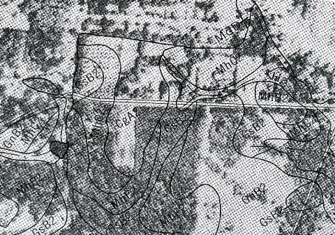
Here is the 1967 soils map that the engineer would have
used to transfer the soils info. It would have been
a difficult job.
__________________________
Please feel free to
contact us
with your own
information on these topics and please be sure
to
contact us
about any information you believe to be
incorrect -
|
|
 Sign up here to receive our periodic Newsloop updates on issues that matter to us all.
Knowledge is power. Stay informed to help shape your community and make a difference.
Abington Township revamped the entire Township website at the end of 2015
and broke all the links to the information. In 2017, under Richard
Manfredi,
someone inexperienced was assigned to redo the entire website again.
The public was not asked what problems they would like to see fixed. Their new plan was
not well thought out, so everything was very hard to find and there were giant
paragraphs you had to slog through in order to find the pertinent one or two
lines that you needed. Or if you were lucky enough to even find the meetings and
agenda page, there was (and still is) a whole page
of nonsense on top, so you think you're on the wrong page. Zoom limks are
burrid in a giant paragraph, so people can't find them to attend the meeting.
They know about these problems - but have just decided to ignore us....
for the whole of Richard Manfredi's time here (with Tom Hecker's consent).
Now, in 2025, we are due to get a new Manager,
and there are funds put aside to, once again, upgrade the Township website. We can only hope for a
fresh chance at fixing some of these things, as our Township website is the best tool we
have for communication and should be an easy, user friendly site for all.
We need volunteers willing to work together to help improve the Township site
that everyone has to use, to make it functional and accessible.
We will be repairing our broken links in this Abington Citizens site,
too, and fixing some of our many, many
typo's as much as is possible. (Yes, it's quite evident that, unlike the
Township, WE don't have a paid staff of 275+ or a $93 million budget).
So...please let us know if you find broken links
or typos. Send us the URL
and/or
and the name of the page it is on, so we can correct it.
Thanks for the help.
DISCLAIMER:
The information in this site, like any site, may have unintentional inaccuracies. These pages also have opinions.
Nothing should not be relied upon as fact until it is confirmed personally by the reader.
Please read our full
Disclaimer
and read our Policies page before using
this site.
Again..... if you find inaccuracies or even grammatical errors, please
contact us so we may correct them.
|